HOW!
The hitch was fine. He told me a bit about the hut, the track and some other tracks on the west coast. He went up to the car park and dropped me there by Kelley's Creek. The track led over a side stream and then it was strait up from there. The track followed what was barely ridge as it climbed the side of the valley in switchbacks that barely traversed. going up you held on to roots and small trees, not so much to keep from falling, but because they were there and you might as well. My pack was full with three days of good food, plus the snow gear that probably wouldn't see any use on the melted tops of the kelly range. The trail took a little traverse at the end of the beech forrest rising slowly into scrub, and then continued with some easy traverses through into the subalpine and alpine regions. I came across some piles of snow, remnants of avalanches mostly. (and there is a lovely little brown creeper (bird) on the rose bush next to me... ). For these sections of snow I got my ice axe out for stability and the off chance that I needed to self arrest. I dropped my water bottle and had to down climb some scree to retrieve it but the snow was fine.
I came up out of the valley and into the basin containing the Carrol hut. patches of snow covering tussocks and sphagnum moss, boulders scattered, and a stream cutting deeply through the middle. I drank in the view up Kelly's creek at the ridge opposite, the otira valley cutting down from the left. I went to a rise, set my pack down and took out my kite to dance in the breeze funneling down the basin. Dancing on the odd puffs and holes that form over the undulating curves of the basin, flying over the edge, a rise, a dip. Looking on and out and over:

Daylight was still abundant and I set my sights on the 1500 m summit nearby. I let the flash hut briefly impress me before setting out with sketchbook and jacket for the slightly snow tops. An easy ridge over the stream led to the north and the summit there. on the one side snow had drifted and been baked by the sun to form a rippling surface. A face bare of snow exposed jagged rocks to the lowering solar disk.


The summit was topped with a research stattion. from there I looked out to the clouds over the west coast, the building rain forecasted for sunday. Below the clouds a river meandered, mirroring the light blue skies above as it did. The clouds themselves blanketed the lower ridges and washed up against the peaks that poked out of the cotton mass. The station had a telephone pole which I climbed up to better feel the wind flowing over that peak. The snow field behind the station was an enticing sledding hill, but I wasn't in the mood for snowy boots. After a few sketches I made my way down to the saddle above the hut. The saddle contained a few scattered tarns: one surrounded in patchy snow in a sea of golden tussock, the other at the bottom of a creeping mass of snow. At the head of the latter a neat cave had formed under the mass of snow. A cave fit for Ludwig's crazy imaginings and Wagner's plays.


I had soon filled my water bottle and was back in the hut steaming vegetables as the sunlight faded from the mountains. No dehydrated food on this trip. Tonight I feasted on quinoa and fresh veggies. I actually made too many veggies and snacked on them all the following day. Before the night finished I tried to catch some alpen glow, some stars. They stretched above, partially hidden by a bright half moon. The milky way was a whiff, but the southern cross and the pointers blazed.

Morning came, I felt as though I had overslept. The hut was cool, but not as cold as I expected. The basin was in shadow and while I ate I waited for the sun to appear. It did, and soon I was following a ridge with it at my back. I decided to leave the route, which passes the tarns of the night before and then traverses the northwest side of the kelly range before descending down to Dillon hut, and follow the ridge-line to the summit of the Kelly Range instead.

A nice mellow walk on gentil slopes. Tussocks and some scattered patches of snow formed the path between patches of scree and the larger boulders scattered about. Some false summits appeared. On the left the slopes steepened to near vertical scree slopes leading into the trees of Kelly's Creek. But on the right were rolling hills of that straw gold tussock. A mellow accent and pleasant foreground for the puffy pillows of cloud that lapped the peaks to the west.
Soon I was at the saddle, a landmark I had identified on my topo after which I would climb to that highest point on the range. Some saddle it was, certainly not a pass, with the scree slopes sliding away to the left. In the middle though was a nice frozen tarn with a small ice fall on it's right bank. farther to the right were more tarns, and just visible was the marked route down to Dillon's hut. Up to the summit: round mellow and bald, not too windy. I got out my topo and assessed the options. It was such a nice day and the prospect of relaxing in a hot pool at Julia hut possesed me. I chose to continue the length of the range and bushwack down to the confluence of Hunt's creek and the Taipo river to then follow the Taipo for some ten kilometers to Julia Hut.

It started out well enough, more pleasant round tops, a nice tarn here, and scree slope there, a snow slope to do a bit of sliding on. The sky was blue and the tops glistened with just a whisper of wind. I dropped down the ridge, sighting my route and was suddenly in dense scrub hiding ankle twisting holes. The scrub soon, but not soon enough, turned to bush. The bush was slightly easier to get through. Now I could descend in a continuous fall, the branches of tress wrapping and tangling around me as a sort of seatbelt that I was continually breaking as I pushed myself down. I could no longer see out of the bush to check and correct my route. I stumbled, bashed, pushed, fell on faith. Now and then in the density of it all a path would seem to appear. I would try to follow it but it would just as soon vanish in the tangle of it all. At last one of these paths sustained long enough for me to feel almost normal... just an overgrown trail. I identified the trail as a deer or goat path by frequent prints in the soft earth. When the trail would vanish I looked to follow the tracks, some times I could, sometimes I couldn't. But now I was continually finding the creatures tracks and soon water soudns could be heard. I hoped it wasnt the gully of Hunts Stream, but I also hoped I wasn't too far west, where the slopes bluffed out above the taipo river. I judged by the sun and wove down the steep slopes. In the end I was a bit into Hunt's Stream gully, but not by much, and  here I found the old, unmaintained path that goes up the gully. So I avoided the bluffs and came out at the water's confluence. Glad to be in the sunshine I crossed Hunt's stream, the Taipo River, then walked up river a bit to some flats and enjoyed a good chow. It was great to recharge and soak up some sun after toiling through the bush for so long. The bush was fun, but a lot of effort. Also there's little sun there so it had felt late in the day. The sun though was just past two - I had all the time in the world for the relativly easy 10km up valley.
here I found the old, unmaintained path that goes up the gully. So I avoided the bluffs and came out at the water's confluence. Glad to be in the sunshine I crossed Hunt's stream, the Taipo River, then walked up river a bit to some flats and enjoyed a good chow. It was great to recharge and soak up some sun after toiling through the bush for so long. The bush was fun, but a lot of effort. Also there's little sun there so it had felt late in the day. The sun though was just past two - I had all the time in the world for the relativly easy 10km up valley. The path stuck to the bank of the Taipo River as it wound up valley. though the way it did varied as the river spread across the valley or squeezed through a neck. First on broad plains with gauss and small shriveled beech like those seen on the snakeskin saddle route. The path vanished in the grasses, washed away by the winter's snow. Red moss covered rocks scattered across a dry braid of stream that occasionally flows from the mountains - a few cairns scattered indicating former trails. Side streams of the Taipo find a more leisurely pace right at the edge of the valley while the river proper flows in the middle. I get to boulder hop across the streams, or wade through them. Orange triangles indicate the trail when there are trees, and a large one calls me up onto the side walls of the valley. Some sections of steep climbing and traversing on steep slopes continue the way where the valley is narrow. Just meters below you can see the River and little side pools through the moss and branches. Some hours pass - another widening, another constriction. At a widening a side trail seemed more worn than the main so I followed it. In a little clearing there stood Mid Taipo hut: a cozy, long, hut with 6 bunks and a nice little stove. I really liked the counter/desk for cooking on. A nice hut to stay at though I didnt much care for the surrounding area, probably good if your hunting in the bush.

The hut marked a mental halfway point to Julia hut. Just after I crossed the Taipo River via a swing bridge. The trail then stayed higher on the bank, with only one or two widening of the valley. Even when it did broaden, the track on the true right of the river, where I was, stayed high while the bush thinned and afforded lovely views of the river and up valley. The valley wall had a curious terrace. It resembled a vehicle track at times, had a stoney surface and many side streams could be seen running into it and then off again. The track followed this groove/stream/terrace for much of the remainder of the day. Going up a hill I debated the journey and the destination and decided it was time for a snack. Not the most scenic, but a good spot to listen and watch the ordinary while enjoying a cliff bar. I noted some nice waterfalls to the side. one I recall was mostly hidden, but roared loudly, and I could just glimpse it's short but broad and mighty cascade through the low trees. The stream it fed was also hidden, flowing semi parallel to the track and then vanishing. The small streams that did cross the path were welcome refreshments for my feet, I didn't try to avoid them but rather plunged my boots in to fill them with cool water. Other parts of the track were clearly used to rain and some people had spent massive amounts of time to lay lots of logs across the trail to control the mud. The laths lent a neat atmosphere to that portion of track. I suddenly began to smell hints of sulfur in the air quite frequently, this egged me on as hot pools were rumored to exist at the hut. I kept my eyes peeled for side trails leading to them. None appeared and the smell came and went along with excitement and disappointment.
 Soon I crossed another creek and then a swing bridge and I saw the Julia hut. I was a bit put off when I looked in and found a cramped little thing with an open fireplace and no mattresses. But that's because it was the old Julia hut! The new one appeared 2 minutes down the track and was super flash. wide open, a powerful little wood stove and mattresses. I went down to the banks of the Taipo to find and explore the hot pools rumered to exist there. Nice little path to there. But I found no pools... I found a bit of warm water in a pool but couldn't make it any bigger. I then found a warm area of sand and dug down tell I hit water, but it didn't come all rushing out. a lot of work to dig out that sand... but also nice to dig in warm sand when all around it is cool.
I noted another likely spot and went back to get make dinner and get my snow shovel. I soon abandoned dinner half made to go work in the light. I prepped the fire before I left and was psyched to find a pick axe as well. More work digging away, moving sand and rocks and I finally had a little hot pool just big enough to curl up in. As night descended I enjoyed the pool, playing with a stream of cold water to get the temperature just right. I moved the sediment around to better cradle my body and used a flat rock for a pillow. I watched the stars come out. The moon shone off and on through the clouds in a lovely glow. I went out and dipped myself in the cold waters of the Taipo a few times in between soaks in the hot sulfur waters. The clouds were coming with night and I knew the night would have rain - I felt a few drops even. One last clear view of the moon in a gap of the clouds and I returned to the hut. I finished my lentils (which I had been soaking the last few days as I tramped up and down it all) into which I added ginger, garlic, onion and spinach on the wood stove which I got roaring away. The hut warmed up nicely and I finished some sketches and enjoyed reading 'Letters from high Latitudes'. That night I fell asleep to the rain and wind on the windows and roof of the hut.
Rain. I new it would come I hoped for the best. Overnight we had gotten a fair bit and the river was much higher. But now the clouds were slightly higher and the rain softer. I enjoyed breakfast on the front porch before packing up, chuckling as I put my ice axe and other snow gear away. Harman pass would have been my preferred route, but the rains would have swollen the river in the gorge and further destabilized snow conditions, plus the clouds were low enough to cause visibility issues. Back down the way I came then!
The path though now was a completely new experience and a fun adventure. In the cool weather the stream were no longer the cool refreshment of the day before, but not cold either. However I now had no choice about wetness as the track itself had become a stream in many places. The section with wood planks laid overtop was less to prevent mud than to stop erosion. Rivulets jumping down past my feet - into my shoes. Flat sections of the terrace became ponds, one was just past my knees at its deepest. Everywhere water was splashing, falling, running. Off cliff walls it launched and I was forced to take a shower where the trail went under one. Another cliff of the day before was completely unrecognizable. I recall it's mossy splendor quite clearly as it was the largest, most consistent, wall of green I had seen yet. a cliff face a few meters high covered in puffy green moss, with little film ferns poking out here and there. an over hang is formed by a large fallen tree. the tree stretches up at an angle into the forest above and is a slide of pure green soft and enticing moss. Now the whole was drenched in water. less serene and hidden was the moss as white foams of water splashed and rushed over and off it onto the track. Further on the track itself became a rushing creek. The thick bush on either side kept me wading downstream as water pushed at my knees and I carefully stepped down from terrace to terrace, trying not to slip, or trip, on the rocks at the transitions. It was nice for a few minutes and then I just wanted to have an inner tube to float the rest of the way.
 I was happy the first stream crossing was a swing bridge, keeping me high and dry over the raging torrent below. I carefully choose a spot to cross the next side stream. The piled rocks that marked its path also diverted it into several smaller braids. I picked my way upstream until I found a good spot to cross the first braid, then searched up and down for safe spots to cross the other two paths. It jumped and tossed about, but it's activity was due to the steep slopes and jumbled rock than to the strength and volume of the flow. Coming to the Taipo (after wading through more flowing streams on the track) I was very glad of the swing bridge which avoided the swiftness that now engulfed the boulders I had seen and photographed yesterday in midstream. I stopped briefly at the Mid Taipo hut to have a snack (a yummy granola bar type cookie I had baked prior to leaving). I was curious to see how the Taipo would be diverted along the flat sections whether it would fill side channels and if so how much.
The streams kept to their own paths on this side of the river, though still crossed the path and lent a nice hazy light to the green mosses about. The flat sections were not much different. One area had almost no flow but was quite deep and lapped the back of my pack. The rain had mostly eased off and only sprayed occasionally. The mountains were obscured though and I recalled the nice peaks I had seen yesterday. I crossed another side river, on the other bank I reconsidered my choice and decided that while I had made it the flow had been rougher and deeper than expected and looking back looked far less crossable. nothing but to continue on now that I was cut off from the Mid Taipo hut. I would use a cable way to cross the Taipo itself further down stream and couldn't recall anymore streams before Dillon hut. I was wrong. After watching a falcon getting assaulted by a smaller bird until they vanished into the clouds I came to another stream. It was diverted in two interweaving braids, but nowhere looked close to crossable. I was stuck between the two streams, and very unhappy.

I marched off up river to see if enough smaller streams entered soon enough to leave a crossable section. This proved to be a very difficult task as the side of the side... gully I guess... were very steep. So more bushwhacking, but this time it was wet, and I kept going down to the river, seeing no crossing and having to climb up the steep slopes to progress past some bluffs and get upstream again. I though I found a spot, but I had doubts and so backed off. returning to the main valley I went up to the ridge line and followed that down, much easier. I wasn't too concerned about having to stay out the night, but was peeved because I had had such poor experiences lighting fires with wood from the bush and there was no chance of finding dry wood. Looking for a good spot to build a shelter I found a likely spot but thought it was a bit far from the trail. I tried to memorize it's location since it also had some dryer wood nearby, and it was close to a side stream on one of the Taipo's flat sections. Once I had determined that it was close enough to the trail and tried to find it again I failed. I settled on another fallen log and set about collecting ferns etc for the shelter: lots of short ferns for the floor (also some odd pine like branches which are hydrophobic and soft), and long ones for the roof. I was content with my shelter, a bit cramped, but looked like it would hold up well. I then continued the more difficult task of finding wood. I found some small things but nothing dry, and so much was rotten. The rain had stopped for a while and some of the dead weeds in the flat plain of the valley had dried to a possibly useful state so I collected a bunch of that as well. Having been at work for some threeish hours and having had little rain I decided to scout the river crossing again. The cairn I had set up to gauge the water level confirmed that the water had indeed lowered (I wasn't just feeling eager to cross). The flow was much reduced and two places showed promise, I took the upstream crossing. Indeed, while I did encounter one spot of strong flow the water level was lower than I would have guessed and I had a very successful crossing.
It was hard to tell the time for sure but I forecasted that I would make Dillon hut just before nightfall. I had consulted my maps again before shelter building and again before committing to the crossing and the way looked clear of further complications. I thought less of the journey now and wished to arrive at the hut. I do recall really liking the flat portions with intermittent stunted beech, the Taipo rushing to my right and the thick bush of the rising slope on my right. I passed where Hunt's stream joined the Taipo, that crossing dint even look remotely possible today. I expected the cable way to appear soon, but instead the track went strait up a scree slope. strait up. I was glad the rain had stopped or I would have been washed off! The it meandered on a ridge for a bit, which was nice but i was nervously thinking I had passed a side trail to the cable way. Finally the track descended, but then descended a lot and I though maybe I had missed it and would have to reclimb the current downclimb (not as steep as the first scree slope). The cable way appeared though the trees, and then at the end of the track.
Crossing was a muscled affair. Tossed my bag and self into the cart using a carabiner to secure my bag so I wouldn't accidently nock it out and assuming that I wouldn't nock myself out. the cart then rolled into the middle of gorge and I had to use a lever that lock against the cable to haul myself and the cart to the other side: one small, slow, strenuous pull at a time. The last meters were hard and the anchor point was in poor shape and made getting my bag out tricky.
The track was along the Taipo and mostly unmarked from there. It lost itself in the yellow (sweet smelling) gauss, into which I was occasionally forced when the trail went into the swollen Taipo). Just before the hut I Passed though an interesting flooded bog. A place influenced by man with a thinned forest and tall none natives snacking like tent poles out of the still water. Rather than find I route around I slowly wadded through the waters, following the trail markers from one green bank to the next. The clouds were turning darker, I still had time before dark but it was coming, which turned the grasses a deeper green that accented the wetness of the air. There was a light drizzle that muffles all sound, no dripping from branch to branch under the skinny trees, or sounds of the Taipo or other running water. Just the ripple of my walk radiating away as I moved through the water.
Dillon hut was nice. The stove was bigger, as was the hut, and took a few tries to light (with dry kindling...) but I did get it roaring. It warmed the hut but not significantly and also provided a nice atmosphere to eat the nights less fancy dinner. Salami, butter, sprouts, tomato, hummus, some scroggin for desert. Sleep came easy as the rain came again and I snuggled in my sleeping bag.
The final exit was an easy two hours. lots of Gauss to start, and a small stream crossing to get my boots wet right form the start! But the clouds lifted to afford wonderful glimpses of dusted mountain sides. The night's rain had fallen as snow on high. Then I followed a side branch of the Taipo that lazily drifted beside me. I was in a nice wide part of the valley now, clear views up and down valley and up the sides to the lower slopes covered in snow. The splotches of sunlight coming in warmed the day and made it a very beautiful morning. Wonderful cascades came down the valley sides. Across the valley a side drainage showed intense erosion with multiple cascades on it's steep faces. A sweet cliff was also visible back from one bank of the Taipo. just like the canyon walls of Utah and Colorado it seemed, but out of sedimentary deposits and with two long flowing water falls just starting to cut notches in. Crossing the side branch was a lovely affair, the slow waters a welcome contrast to the flows of the day before was coupled with a spot of sunshine.
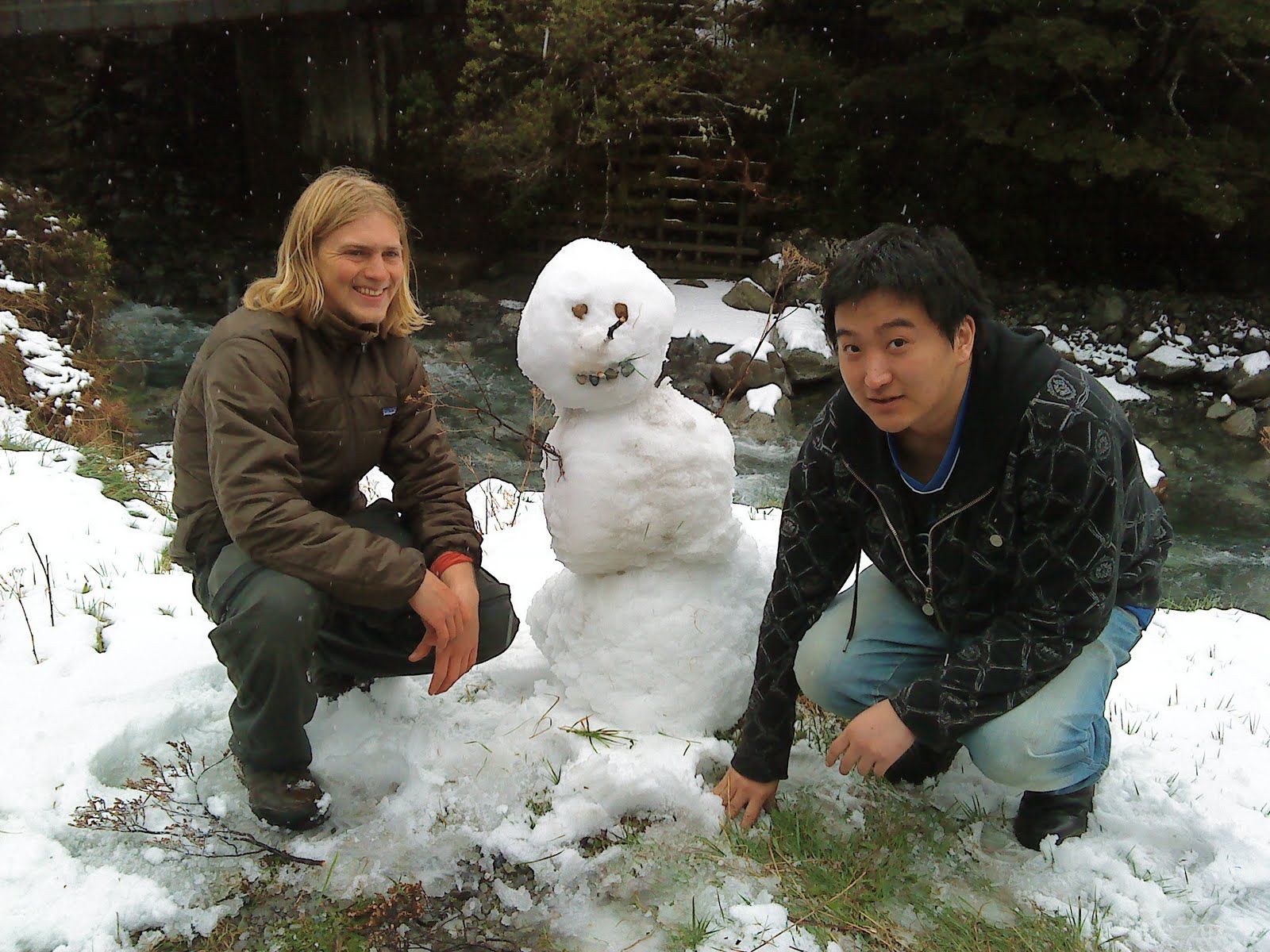
I crossed a little ridge. Leaving the Taipo behind, I was on the road of pass. Rain came in spurts, traffic was slow. I took out my sketch book to sketch the view accross the valley while I waited. The farmer of the farm where I was waited came and gave me a lift to jackson, a town just out of Arthur's Pass that gets traffic from both Hokitika and Greymouth. From there I got a lift in a nice yellow Honda from some asians. One had never seen snow and we stopped in Arthur's Pass to catch snow flakes, throw a snowball and make a snowman. Later we also stopped at castle hill where I gave them a short tour. They dropped me back in Christchurch with just enough time to walk to uni and make the last rehearsal for Kapa Haka! (but no one remarked on my appearance or tramping gear).

This is a trip report of my less than snowy wanderings on the kelly range with sun and moon. Then changing plans and bushwhacking to Juli a hut and a hot pool fire and lentils. Next day is a crazy affair of rain and swollen streams, creeks and rivers as I descended out the Taipo river valley.
ReplyDelete